1 Introduction
1.1 Objective of the study
1.2 Market Definitions
1.3 Market Segmentation & Aspects Covered
1.4 Research Methodology
1.4.1 Assumptions (Market Size, Forecast, etc)
2 Executive Summary
3 Market Overview
4 LiDAR-Asia-Pacific, By Applications
4.1 Split By Geography
4.1 LiDAR-Asia-Pacific Others by Applications
4.1 LiDAR-China by Applications
4.1 LiDAR-India by Applications
4.1 LiDAR-Japan by Applications
4.1 LiDAR-South Korea by Applications
4.1 LiDAR-Taiwan (Republic of China) by Applications
4.2 LiDAR-Asia-Pacific-Volumetric Mapping
4.2.1 LiDAR-Asia-Pacific-Volumetric Mapping, By Geographies
4.2.1.1 LiDAR-China-Volumetric Mapping
4.2.1.2 LiDAR-India-Volumetric Mapping
4.2.1.3 LiDAR-Japan-Volumetric Mapping
4.2.1.4 LiDAR-South Korea-Volumetric Mapping
4.2.1.5 LiDAR-Taiwan (Republic of China)-Volumetric Mapping
4.2.2 LiDAR-Asia-Pacific-Volumetric Mapping, By Products
4.2.2.1 Airborne LiDAR-Asia-Pacific-Volumetric Mapping
4.2.2.2 Terrestrial LiDAR-Asia-Pacific-Volumetric Mapping
4.2.2.3 Short Range LiDAR-Asia-Pacific-Volumetric Mapping
4.2.2.4 Mobile LiDAR-Asia-Pacific-Volumetric Mapping
4.3 LiDAR-Asia-Pacific-Topographic surveys
4.3.1 LiDAR-Asia-Pacific-Topographic surveys, By Geographies
4.3.1.1 LiDAR-China-Topographic surveys
4.3.1.2 LiDAR-India-Topographic surveys
4.3.1.3 LiDAR-Japan-Topographic surveys
4.3.1.4 LiDAR-South Korea-Topographic surveys
4.3.1.5 LiDAR-Taiwan (Republic of China)-Topographic surveys
4.3.2 LiDAR-Asia-Pacific-Topographic surveys, By Products
4.3.2.1 Airborne LiDAR-Asia-Pacific-Topographic surveys
4.3.2.2 Terrestrial LiDAR-Asia-Pacific-Topographic surveys
4.3.2.3 Short Range LiDAR-Asia-Pacific-Topographic surveys
4.3.2.4 Mobile LiDAR-Asia-Pacific-Topographic surveys
4.4 LiDAR-Asia-Pacific-Corridor Mapping
4.4.1 LiDAR-Asia-Pacific-Corridor Mapping, By Geographies
4.4.1.1 LiDAR-China-Corridor Mapping
4.4.1.2 LiDAR-India-Corridor Mapping
4.4.1.3 LiDAR-Japan-Corridor Mapping
4.4.1.4 LiDAR-South Korea-Corridor Mapping
4.4.1.5 LiDAR-Taiwan (Republic of China)-Corridor Mapping
4.4.2 LiDAR-Asia-Pacific-Corridor Mapping, By Products
4.4.2.1 Airborne LiDAR-Asia-Pacific-Corridor Mapping
4.4.2.2 Terrestrial LiDAR-Asia-Pacific-Corridor Mapping
4.4.2.3 Short Range LiDAR-Asia-Pacific-Corridor Mapping
4.4.2.4 Mobile LiDAR-Asia-Pacific-Corridor Mapping
4.5 LiDAR-Asia-Pacific-Other Applications
4.5.1 LiDAR-Asia-Pacific-Other Applications, By Geographies
4.5.1.1 LiDAR-China-Other Applications
4.5.1.2 LiDAR-India-Other Applications
4.5.1.3 LiDAR-Japan-Other Applications
4.5.1.4 LiDAR-South Korea-Other Applications
4.5.1.5 LiDAR-Taiwan (Republic of China)-Other Applications
4.5.2 LiDAR-Asia-Pacific-Other Applications, By Products
4.5.2.1 Airborne LiDAR-Asia-Pacific-Other Applications
4.5.2.2 Terrestrial LiDAR-Asia-Pacific-Other Applications
4.5.2.3 Short Range LiDAR-Asia-Pacific-Other Applications
4.5.2.4 Mobile LiDAR-Asia-Pacific-Other Applications
4.6 LiDAR-Asia-Pacific-Building/Infrastructure
4.6.1 LiDAR-Asia-Pacific-Building/Infrastructure, By Geographies
4.6.1.1 LiDAR-China-Building/Infrastructure
4.6.1.2 LiDAR-India-Building/Infrastructure
4.6.1.3 LiDAR-Japan-Building/Infrastructure
4.6.1.4 LiDAR-South Korea-Building/Infrastructure
4.6.1.5 LiDAR-Taiwan (Republic of China)-Building/Infrastructure
4.6.2 LiDAR-Asia-Pacific-Building/Infrastructure, By Products
4.6.2.1 Short Range LiDAR-Asia-Pacific-Building/Infrastructure
4.6.2.2 Mobile LiDAR-Asia-Pacific-Building/Infrastructure
4.6.2.3 Airborne LiDAR-Asia-Pacific-Building/Infrastructure
4.6.2.4 Terrestrial LiDAR-Asia-Pacific-Building/Infrastructure
4.7 LiDAR-Asia-Pacific-Military
4.7.1 LiDAR-Asia-Pacific-Military, By Geographies
4.7.1.1 LiDAR-China-Military
4.7.1.2 LiDAR-India-Military
4.7.1.3 LiDAR-Japan-Military
4.7.1.4 LiDAR-South Korea-Military
4.7.1.5 LiDAR-Taiwan (Republic of China)-Military
4.7.2 LiDAR-Asia-Pacific-Military, By Products
4.7.2.1 Short Range LiDAR-Asia-Pacific-Military
4.7.2.2 Mobile LiDAR-Asia-Pacific-Military
4.7.2.3 Airborne LiDAR-Asia-Pacific-Military
4.7.2.4 Terrestrial LiDAR-Asia-Pacific-Military
4.8 LiDAR-Asia-Pacific-Public Sector/Service
4.8.1 LiDAR-Asia-Pacific-Public Sector/Service, By Geographies
4.8.1.1 LiDAR-China-Public Sector/Service
4.8.1.2 LiDAR-India-Public Sector/Service
4.8.1.3 LiDAR-Japan-Public Sector/Service
4.8.1.4 LiDAR-South Korea-Public Sector/Service
4.8.1.5 LiDAR-Taiwan (Republic of China)-Public Sector/Service
4.8.2 LiDAR-Asia-Pacific-Public Sector/Service, By Products
4.8.2.1 Short Range LiDAR-Asia-Pacific-Public Sector/Service
4.8.2.2 Mobile LiDAR-Asia-Pacific-Public Sector/Service
4.8.2.3 Airborne LiDAR-Asia-Pacific-Public Sector/Service
4.8.2.4 Terrestrial LiDAR-Asia-Pacific-Public Sector/Service
5 LiDAR-Asia-Pacific, By Products
5.1 Split By Geography
5.2 LiDAR-Asia-Pacific Others by Products
5.1 LiDAR-China by Products
5.1 LiDAR-India by Products
5.1 LiDAR-Japan by Products
5.1 LiDAR-South Korea by Products
5.1 LiDAR-Taiwan (Republic of China) by Products
5.2 Short Range LiDAR-Asia-Pacific
5.2.1 Short Range LiDAR-Asia-Pacific, By Applications
5.2.1.1 Short Range LiDAR-Asia-Pacific-Other Applications
5.2.1.2 Short Range LiDAR-Asia-Pacific-Topographic surveys
5.2.1.3 Short Range LiDAR-Asia-Pacific-Public Sector/Service
5.2.1.4 Short Range LiDAR-Asia-Pacific-Military
5.2.1.5 Short Range LiDAR-Asia-Pacific-Volumetric Mapping
5.2.1.6 Short Range LiDAR-Asia-Pacific-Building/Infrastructure
5.2.1.7 Short Range LiDAR-Asia-Pacific-Corridor Mapping
5.2.2 Short Range LiDAR-Asia-Pacific, By Geographies
5.2.2.1 Short Range LiDAR-China
5.2.2.2 Short Range LiDAR-India
5.2.2.3 Short Range LiDAR-Japan
5.2.2.4 Short Range LiDAR-South Korea
5.2.2.5 Short Range LiDAR-Taiwan (Republic of China)
5.3 Mobile LiDAR-Asia-Pacific
5.3.1 Mobile LiDAR-Asia-Pacific, By Applications
5.3.1.1 Mobile LiDAR-Asia-Pacific-Building/Infrastructure
5.3.1.2 Mobile LiDAR-Asia-Pacific-Military
5.3.1.3 Mobile LiDAR-Asia-Pacific-Volumetric Mapping
5.3.1.4 Mobile LiDAR-Asia-Pacific-Other Applications
5.3.1.5 Mobile LiDAR-Asia-Pacific-Corridor Mapping
5.3.1.6 Mobile LiDAR-Asia-Pacific-Topographic surveys
5.3.1.7 Mobile LiDAR-Asia-Pacific-Public Sector/Service
5.3.2 Mobile LiDAR-Asia-Pacific, By Geographies
5.3.2.1 Mobile LiDAR-China
5.3.2.2 Mobile LiDAR-India
5.3.2.3 Mobile LiDAR-Japan
5.3.2.4 Mobile LiDAR-South Korea
5.3.2.5 Mobile LiDAR-Taiwan (Republic of China)
5.4 Airborne LiDAR-Asia-Pacific
5.4.1 Airborne LiDAR-Asia-Pacific, By Applications
5.4.1.1 Airborne LiDAR-Asia-Pacific-Public Sector/Service
5.4.1.2 Airborne LiDAR-Asia-Pacific-Topographic surveys
5.4.1.3 Airborne LiDAR-Asia-Pacific-Military
5.4.1.4 Airborne LiDAR-Asia-Pacific-Building/Infrastructure
5.4.1.5 Airborne LiDAR-Asia-Pacific-Volumetric Mapping
5.4.1.6 Airborne LiDAR-Asia-Pacific-Corridor Mapping
5.4.1.7 Airborne LiDAR-Asia-Pacific-Other Applications
5.4.2 Airborne LiDAR-Asia-Pacific, By Geographies
5.4.2.1 Airborne LiDAR-China
5.4.2.2 Airborne LiDAR-India
5.4.2.3 Airborne LiDAR-Japan
5.4.2.4 Airborne LiDAR-South Korea
5.4.2.5 Airborne LiDAR-Taiwan (Republic of China)
5.5 Terrestrial LiDAR-Asia-Pacific
5.5.1 Terrestrial LiDAR-Asia-Pacific, By Applications
5.5.1.1 Terrestrial LiDAR-Asia-Pacific-Volumetric Mapping
5.5.1.2 Terrestrial LiDAR-Asia-Pacific-Corridor Mapping
5.5.1.3 Terrestrial LiDAR-Asia-Pacific-Building/Infrastructure
5.5.1.4 Terrestrial LiDAR-Asia-Pacific-Military
5.5.1.5 Terrestrial LiDAR-Asia-Pacific-Other Applications
5.5.1.6 Terrestrial LiDAR-Asia-Pacific-Public Sector/Service
5.5.1.7 Terrestrial LiDAR-Asia-Pacific-Topographic surveys
5.5.2 Terrestrial LiDAR-Asia-Pacific, By Geographies
5.5.2.1 Terrestrial LiDAR-China
5.5.2.2 Terrestrial LiDAR-India
5.5.2.3 Terrestrial LiDAR-Japan
5.5.2.4 Terrestrial LiDAR-South Korea
5.5.2.5 Terrestrial LiDAR-Taiwan (Republic of China)
6 LiDAR-Asia-Pacific, By Geographies
6.1 LiDAR-Asia-Pacific Others
6.2 LiDAR-China
6.2.1 LiDAR-China, By Applications
6.2.1.1 LiDAR-China-Building/Infrastructure
6.2.1.2 LiDAR-China-Volumetric Mapping
6.2.1.3 LiDAR-China-Military
6.2.1.4 LiDAR-China-Public Sector/Service
6.2.1.5 LiDAR-China-Topographic surveys
6.2.1.6 LiDAR-China-Corridor Mapping
6.2.1.7 LiDAR-China-Other Applications
6.2.2 LiDAR-China, By Companies
6.2.2.1 LiDAR-China-Optech Inc.
6.2.2.2 LiDAR-China-Leica Geosystems
6.2.2.3 LiDAR-China-Trimble Navigation Limited
6.2.2.4 LiDAR-China-Topcon corporation
6.2.2.5 LiDAR-China-Velodyne Lidar INC.
6.2.2.6 LiDAR-China-AeroMetric
6.2.2.7 LiDAR-China-Raymetrics
6.2.2.8 LiDAR-China-Pix4D
6.2.2.9 LiDAR-China-IGI mBH
6.2.2.10 LiDAR-China-Riegl USA
6.2.2.11 LiDAR-China-Faro Technology
6.2.2.12 LiDAR-China-Intermap Technologies
6.2.3 LiDAR-China, By Products
6.2.3.1 Short Range LiDAR-China
6.2.3.2 Mobile LiDAR-China
6.2.3.3 Airborne LiDAR-China
6.2.3.4 Terrestrial LiDAR-China
6.3 LiDAR-India
6.3.1 LiDAR-India, By Applications
6.3.1.1 LiDAR-India-Building/Infrastructure
6.3.1.2 LiDAR-India-Volumetric Mapping
6.3.1.3 LiDAR-India-Military
6.3.1.4 LiDAR-India-Public Sector/Service
6.3.1.5 LiDAR-India-Topographic surveys
6.3.1.6 LiDAR-India-Corridor Mapping
6.3.1.7 LiDAR-India-Other Applications
6.3.2 LiDAR-India, By Companies
6.3.2.1 LiDAR-India-Optech Inc.
6.3.2.2 LiDAR-India-Leica Geosystems
6.3.2.3 LiDAR-India-Trimble Navigation Limited
6.3.2.4 LiDAR-India-Topcon corporation
6.3.2.5 LiDAR-India-Velodyne Lidar INC.
6.3.2.6 LiDAR-India-AeroMetric
6.3.2.7 LiDAR-India-Raymetrics
6.3.2.8 LiDAR-India-Pix4D
6.3.2.9 LiDAR-India-IGI mBH
6.3.2.10 LiDAR-India-Riegl USA
6.3.2.11 LiDAR-India-Faro Technology
6.3.2.12 LiDAR-India-Intermap Technologies
6.3.3 LiDAR-India, By Products
6.3.3.1 Short Range LiDAR-India
6.3.3.2 Mobile LiDAR-India
6.3.3.3 Airborne LiDAR-India
6.3.3.4 Terrestrial LiDAR-India
6.4 LiDAR-Japan
6.4.1 LiDAR-Japan, By Applications
6.4.1.1 LiDAR-Japan-Building/Infrastructure
6.4.1.2 LiDAR-Japan-Volumetric Mapping
6.4.1.3 LiDAR-Japan-Military
6.4.1.4 LiDAR-Japan-Public Sector/Service
6.4.1.5 LiDAR-Japan-Topographic surveys
6.4.1.6 LiDAR-Japan-Corridor Mapping
6.4.1.7 LiDAR-Japan-Other Applications
6.4.2 LiDAR-Japan, By Companies
6.4.2.1 LiDAR-Japan-Optech Inc.
6.4.2.2 LiDAR-Japan-Leica Geosystems
6.4.2.3 LiDAR-Japan-Trimble Navigation Limited
6.4.2.4 LiDAR-Japan-Topcon corporation
6.4.2.5 LiDAR-Japan-Velodyne Lidar INC.
6.4.2.6 LiDAR-Japan-AeroMetric
6.4.2.7 LiDAR-Japan-Raymetrics
6.4.2.8 LiDAR-Japan-Pix4D
6.4.2.9 LiDAR-Japan-IGI mBH
6.4.2.10 LiDAR-Japan-Riegl USA
6.4.2.11 LiDAR-Japan-Faro Technology
6.4.2.12 LiDAR-Japan-Intermap Technologies
6.4.3 LiDAR-Japan, By Products
6.4.3.1 Short Range LiDAR-Japan
6.4.3.2 Mobile LiDAR-Japan
6.4.3.3 Airborne LiDAR-Japan
6.4.3.4 Terrestrial LiDAR-Japan
6.5 LiDAR-South Korea
6.5.1 LiDAR-South Korea, By Applications
6.5.1.1 LiDAR-South Korea-Building/Infrastructure
6.5.1.2 LiDAR-South Korea-Volumetric Mapping
6.5.1.3 LiDAR-South Korea-Military
6.5.1.4 LiDAR-South Korea-Public Sector/Service
6.5.1.5 LiDAR-South Korea-Topographic surveys
6.5.1.6 LiDAR-South Korea-Corridor Mapping
6.5.1.7 LiDAR-South Korea-Other Applications
6.5.2 LiDAR-South Korea, By Companies
6.5.2.1 LiDAR-South Korea-Optech Inc.
6.5.2.2 LiDAR-South Korea-Leica Geosystems
6.5.2.3 LiDAR-South Korea-Trimble Navigation Limited
6.5.2.4 LiDAR-South Korea-Topcon corporation
6.5.2.5 LiDAR-South Korea-Velodyne Lidar INC.
6.5.2.6 LiDAR-South Korea-AeroMetric
6.5.2.7 LiDAR-South Korea-Raymetrics
6.5.2.8 LiDAR-South Korea-Pix4D
6.5.2.9 LiDAR-South Korea-IGI mBH
6.5.2.10 LiDAR-South Korea-Riegl USA
6.5.2.11 LiDAR-South Korea-Faro Technology
6.5.2.12 LiDAR-South Korea-Intermap Technologies
6.5.3 LiDAR-South Korea, By Products
6.5.3.1 Short Range LiDAR-South Korea
6.5.3.2 Mobile LiDAR-South Korea
6.5.3.3 Airborne LiDAR-South Korea
6.5.3.4 Terrestrial LiDAR-South Korea
6.6 LiDAR-Taiwan (Republic of China)
6.6.1 LiDAR-Taiwan (Republic of China), By Applications
6.6.1.1 LiDAR-Taiwan (Republic of China)-Building/Infrastructure
6.6.1.2 LiDAR-Taiwan (Republic of China)-Volumetric Mapping
6.6.1.3 LiDAR-Taiwan (Republic of China)-Military
6.6.1.4 LiDAR-Taiwan (Republic of China)-Public Sector/Service
6.6.1.5 LiDAR-Taiwan (Republic of China)-Topographic surveys
6.6.1.6 LiDAR-Taiwan (Republic of China)-Corridor Mapping
6.6.1.7 LiDAR-Taiwan (Republic of China)-Other Applications
6.6.2 LiDAR-Taiwan (Republic of China), By Companies
6.6.2.1 LiDAR-Taiwan (Republic of China)-Optech Inc.
6.6.2.2 LiDAR-Taiwan (Republic of China)-Leica Geosystems
6.6.2.3 LiDAR-Taiwan (Republic of China)-Trimble Navigation Limited
6.6.2.4 LiDAR-Taiwan (Republic of China)-Topcon corporation
6.6.2.5 LiDAR-Taiwan (Republic of China)-Velodyne Lidar INC.
6.6.3 LiDAR-Taiwan (Republic of China), By Products
6.6.3.1 Short Range LiDAR-Taiwan (Republic of China)
6.6.3.2 Mobile LiDAR-Taiwan (Republic of China)
6.6.3.3 Airborne LiDAR-Taiwan (Republic of China)
6.6.3.4 Terrestrial LiDAR-Taiwan (Republic of China)
7 LiDAR-Asia-Pacific, By Companies
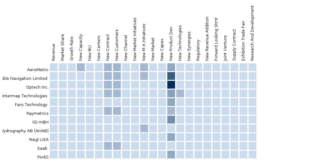
7.1 Competitive landscape
7.2 Split By Geography
7.3 LiDAR-Asia-Pacific Others by Companies
7.1 LiDAR-China by Companies
7.1 LiDAR-India by Companies
7.1 LiDAR-Japan by Companies
7.1 LiDAR-South Korea by Companies
7.1 LiDAR-Taiwan (Republic of China) by Companies
7.3 LiDAR-Asia-Pacific-Optech Inc.
7.3.1 LiDAR-Asia-Pacific-Optech Inc., By Geographies
7.3.1.1 LiDAR-China-Optech Inc.
7.3.1.2 LiDAR-India-Optech Inc.
7.3.1.3 LiDAR-Japan-Optech Inc.
7.3.1.4 LiDAR-South Korea-Optech Inc.
7.3.1.5 LiDAR-Taiwan (Republic of China)-Optech Inc.
7.4 LiDAR-Asia-Pacific-Leica Geosystems
7.4.1 LiDAR-Asia-Pacific-Leica Geosystems, By Geographies
7.4.1.1 LiDAR-China-Leica Geosystems
7.4.1.2 LiDAR-India-Leica Geosystems
7.4.1.3 LiDAR-Japan-Leica Geosystems
7.4.1.4 LiDAR-South Korea-Leica Geosystems
7.4.1.5 LiDAR-Taiwan (Republic of China)-Leica Geosystems
7.5 LiDAR-Asia-Pacific-Trimble Navigation Limited
7.5.1 LiDAR-Asia-Pacific-Trimble Navigation Limited , By Geographies
7.5.1.1 LiDAR-China-Trimble Navigation Limited
7.5.1.2 LiDAR-India-Trimble Navigation Limited
7.5.1.3 LiDAR-Japan-Trimble Navigation Limited
7.5.1.4 LiDAR-South Korea-Trimble Navigation Limited
7.5.1.5 LiDAR-Taiwan (Republic of China)-Trimble Navigation Limited
7.6 LiDAR-Asia-Pacific-Topcon corporation
7.6.1 LiDAR-Asia-Pacific-Topcon corporation, By Geographies
7.6.1.1 LiDAR-China-Topcon corporation
7.6.1.2 LiDAR-India-Topcon corporation
7.6.1.3 LiDAR-Japan-Topcon corporation
7.6.1.4 LiDAR-South Korea-Topcon corporation
7.6.1.5 LiDAR-Taiwan (Republic of China)-Topcon corporation
7.7 LiDAR-Asia-Pacific-Velodyne Lidar INC.
7.7.1 LiDAR-Asia-Pacific-Velodyne Lidar INC., By Geographies
7.7.1.1 LiDAR-China-Velodyne Lidar INC.
7.7.1.2 LiDAR-India-Velodyne Lidar INC.
7.7.1.3 LiDAR-Japan-Velodyne Lidar INC.
7.7.1.4 LiDAR-South Korea-Velodyne Lidar INC.
7.7.1.5 LiDAR-Taiwan (Republic of China)-Velodyne Lidar INC.
7.8 LiDAR-Asia-Pacific-Faro Technology
7.8.1 LiDAR-Asia-Pacific-Faro Technology , By Geographies
7.8.1.1 LiDAR-China-Faro Technology
7.8.1.2 LiDAR-India-Faro Technology
7.8.1.3 LiDAR-Japan-Faro Technology
7.8.1.4 LiDAR-South Korea-Faro Technology
7.9 LiDAR-Asia-Pacific-Intermap Technologies
7.9.1 LiDAR-Asia-Pacific-Intermap Technologies , By Geographies
7.9.1.1 LiDAR-China-Intermap Technologies
7.9.1.2 LiDAR-India-Intermap Technologies
7.9.1.3 LiDAR-Japan-Intermap Technologies
7.9.1.4 LiDAR-South Korea-Intermap Technologies
7.10 LiDAR-Asia-Pacific-Saab
7.11 LiDAR-Asia-Pacific-AeroMetric
7.11.1 LiDAR-Asia-Pacific-AeroMetric, By Geographies
7.11.1.1 LiDAR-China-AeroMetric
7.11.1.2 LiDAR-India-AeroMetric
7.11.1.3 LiDAR-Japan-AeroMetric
7.11.1.4 LiDAR-South Korea-AeroMetric
7.12 LiDAR-Asia-Pacific-IGI mBH
7.12.1 LiDAR-Asia-Pacific-IGI mBH, By Geographies
7.12.1.1 LiDAR-China-IGI mBH
7.12.1.2 LiDAR-India-IGI mBH
7.12.1.3 LiDAR-Japan-IGI mBH
7.12.1.4 LiDAR-South Korea-IGI mBH
7.13 LiDAR-Asia-Pacific-Pix4D
7.13.1 LiDAR-Asia-Pacific-Pix4D, By Geographies
7.13.1.1 LiDAR-China-Pix4D
7.13.1.2 LiDAR-India-Pix4D
7.13.1.3 LiDAR-Japan-Pix4D
7.13.1.4 LiDAR-South Korea-Pix4D
7.14 LiDAR-Asia-Pacific-Raymetrics
7.14.1 LiDAR-Asia-Pacific-Raymetrics, By Geographies
7.14.1.1 LiDAR-China-Raymetrics
7.14.1.2 LiDAR-India-Raymetrics
7.14.1.3 LiDAR-Japan-Raymetrics
7.14.1.4 LiDAR-South Korea-Raymetrics
7.15 LiDAR-Asia-Pacific-Riegl USA
7.15.1 LiDAR-Asia-Pacific-Riegl USA, By Geographies
7.15.1.1 LiDAR-China-Riegl USA
7.15.1.2 LiDAR-India-Riegl USA
7.15.1.3 LiDAR-Japan-Riegl USA
7.15.1.4 LiDAR-South Korea-Riegl USA